Licence Majeure LLCE Anglais Année Universitaire 2007-08
Civilisation (US)
Geography, both physical & human
Students are encouraged to return from time to time to this page, which will very probably be modified and expanded as time goes on : Check the section below on "Cities, states and regions", which has been significantly updated.
Political & Economic Geography
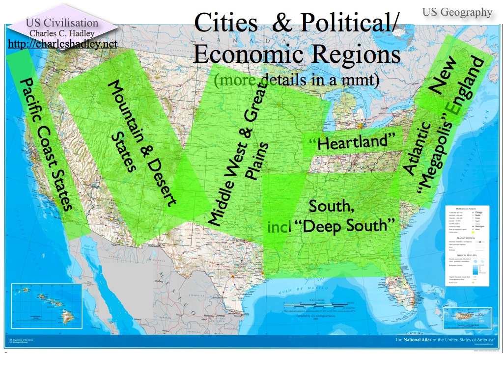
The main geographic regions of the US, both from a geological and an economic point of view, are New England, the "Atlantic Megalopolis", the "Heartland", the South (including the Deep South), the Middle West and Great Plains, the Mountain & Desert States, and the Pacific Coast. (map with labels)
- New England, the Atlantic Megalopolis, the Heartland and parts of the Pacific Coast are heavily urbanized, while the other regions are less markedly characterized by urban development, and in some cases distinctly rural. The map of population density that can be found a the National Atlas website (here) gives an idea of how people are distributed in the contiguous forty-eight. (Click on People in the menu bar at the top, then on Population Density 2000 in the Map Maker Samples section on the right. White represents lowest density, yellow low density, and blue high density). Another way of seeing where population density is highest is to look at a satellite photo taken at night (available here at the University of Georgia site), in which urban regions are brightly lit up.
- It should be noted that though the term "regions" has become a common way of talking about parts of the United States, the regions are not administrative entities like the "régions" in France, but rather ad hoc designations of areas with shared geological and economic features; only the states have a legal status in the political geography of the US.
Typical City Structure
Cities in the US often share a characteristic urban structure, the outcome of the historical development of the city. Frequently, the city's official borders, determined by state legislation are not identical with those of the historic center, that is, the part where the earliest town was first constructed. The center, furthermore, can often be observed to have developed into two very distinct parts:
- the "downtown", i.e., the business center, where financial transactions in banks and company headquarters mean that large amounts of money are exchanged and made
and
- the "inner city", once the residences of the wealthy merchants and bankers that worked in the downtown area, but subsequently allowed to decline and decay and now left as dwellings for the poor, often ethnic minorities. Unemployment, crime and the ills of poverty are often rampant in inner cities.
- The well-to-do employees and executives that work in the downtowns most often do not live within the city limits, but rather commute back and forth between their places of employement and the suburbs that surround the city proper.
As a consequence of this drain of wealth from the city, and the resultant concentration of poverty in the inner cities, city governments are frequently hard put to find the tax revenues necessary to provide and maintain adequate infrastructure, a situation which naturally tends to drive away prospective new-comers, who thus do not bring their tax dollars to the assistance of the city.
Instead of settling within the city-limits, they often go to join the well-to-do who work in the downtown, but who, far from living in the inner city, reside in wealthy suburbs, with well-kept streets, high-quality schools and all the well-equipped municipal services needed to maintain them. *
Cities, states and regions
Cities (and the states they are in, if only because the creation of cities is another example of the functioning of federalism) that students should know something about, including where to find them on the map, include [map with arrows]:
[Back to top of page]
- four in the "Atlantic Megalopolis" (click the link for more on these cities)
- Boston, MA (MA is the Post Office abbreviation for Massachusetts)
- New York, NY (NY is the PO abbreviation for [the state of] New York)
- Philadelphia, PA (Pennsylvania)
- Washington, D.C. (District of Columbia)
- four in the Heartland & Middle West
The geographic area between Pittsburgh in the east and Detroit in the west was extremely oriented for many years toward heavy industrial production. During the 1970s and 80s, much of the area's primacy in that domain was lost to other countries; as a result the
- Pittsburgh, PA
- Best known as the center for the production of steel.
- Detroit, MI (Michigan)
- Best known as the center for the production of autos (General Motors, Ford and Chrysler all have and have always had major plants in and around Detroit).
- Chicago, IL (Illinois)
- Third largest city in US (population just less than 3,000,000 in 2000): on the west side of Lake Michigan; grew from a small village (less than twenty houses) in 1830 to a city of close to 3,000,000 today; highly diversified economy, including transportation (water [Lake Michigan], rail, air [O'Hare Airport is one of the busiest in the world]) industry (manufacturing heavy agricultural equipment, processing agricultural products into food, etc); financial markets; spectacular lake-front sky-line
- Saint Louis, MO (Missouri)
- Major river transportation center (on banks of Mississippi River); arch symbolizing St Louis's position as the gateway to the west
[Back to top of page]
- four in the South
- Miami, FL (Florida)
- Among the first US cities to have a majority of Spanish speakers. Well-known for mild, sem-tropical climate, which has attracted retirees for generations; Florida beach cities also attract college students for a week of wild partying during "spring break".
- Atlanta, GA (Georgia)
- Utterly destroyed by Union army during the Civil War, reborn from its own ashes to become one the South's most economically dynamic cities; now world headquarters for Coca-Cola and CNN; [right now (20/10/2007) Atlanta and many cities of the Deep South are suffering from an extremely unusual drought; according to some experts Atlanta's supply of drinking water may be used up within four months...]
- New Orleans, LA (Louisiana)
- Large areas of New Orleans were destroyed by Hurricane Katrina at the end of the summer of 2005, leaving tens of thousands of people homeless, and profoundly changing the demographics of the city, as many who left to find shelter elsewhere have not returned. New Orleans's economy depends partly on its strategic location near the mouth of the Mississippi, making of it a hub of water transportation, and partly (for many years at least) on its special role as a center of jazz culture [Katrina drove out many of the African-Americans who contributed to this aspect of New Orleans, and reconstruction efforts have been only very moderately successful in bringing them back]. New Orleans is also known for its French heritage: a whole French Quarter shows the influence of early colonization and settlement.
- Houston, TX (Texas)
- Houston is also a port city; during the 1970s and 80s an economic boom linked with off-shore petroleum drilling contributed to making Houston into a major regional economic center. It is also the headquarters of NASA: when astronauts are in space, they communicate with the center at Houston "Mission Control".
[Back to top of page]
- three in the Mountain & Desert States
- Denver, CO (Colorado)
- Salt Lake City, UT (Utah)
- Salt Lake has played a role in US religious history as well as in the history of expansion toward the West: the city was founded in the 1840s by the Mormons, who had been persecuted and driven out of a number of states in the East. They succeeded in establishing what would become a thriving city in a very inhospitable environment, on the banks of a salt lake, with very little fresh water. Today Salt Lake is still the center of Mormonism throughout the world.
- Phoenix, AZ (Arizona)
- Unusual in being a desert city (though in this similar to Salt Lake), and in being bounded on one side by the enormous Native American reservation that occupies much of Arizona and New Mexico. Its dry climate has attracted not only retirees but many high-tech professionals.
[Back to top of page]
- four in the Pacific Coast states (situated on the Pacific coast, geology makes all of these cities vulnerable to various forms of geo-seismic activity, whether volcanoes in Washington or Oregon, or earthquakes in California)
- Seattle, WA (Washington [the state, not to be confused with the city of Washington, D.C.])
- Not far from Mount St Helen, an active volcano that has erupted several times in the last twenty or thirty years; headquarters of Boeing Aircraft and Microsoft. Generally mild climate, very humid.
- San Francisco, CA (California)
- Los Angeles, CA
- San Diego, CA
[Back to top of page]
__________
Université Jean-Moulin - Lyon 3
Faculté des Langues
Charles C. Hadley 2007-08
This page was last updated on vendredi 25 janvier 2008 at
17:26